How satellite observations help lessen the contribution of agriculture to climate change

CGIAR focuses on the transformation of rural farming food systems through better agriculture to help communities adapt to complex and integrated challenges such as climate change and population growth, and provide food and water security, and more resilient livelihoods. Yet ironically, agriculture is both a victim and a contributor to climate change, water scarcity, and air pollution. It follows then that unless carefully planned through informed decision-making, achieving food security through better agriculture, may amplify the threats and challenges. The key is to understand what agricultural activities make the situation worse or improve it and focus on the better option.
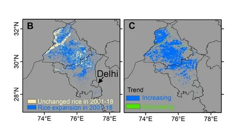
Scientists including ICARDA scientist Dr. Chandrashekhar Biradar investigated the impact of cropping patterns and policies on the food, water, and air quality over the decades and have now published an open-access paper in Elsevier, Global Environmental Change. The study used remote sensing technology over the food basket of India, where one-fifth of the country’s wheat is produced and where paddy rice areas are significantly increasing.
Based on observations from multiple satellites from 2001 to 2018, the scientists found that paddy rice expansion increased groundwater depletion by 1.50 cm per year. As well as this, residue burning was increased by 500%, which was a factor for air pollution increases of more than 29% in the region.
Satellite observations also showed that an enactment of a groundwater protection policy in 2009 significantly decelerated groundwater depletion due to delayed rice planting and harvest dates.
With such clear results, the study recommends urgently required actions and new policies for sustainable development to resolve the trade-offs of the food-water–air quality challenge in northern India. These include:
-
A more efficient crop residue utilization and management system,
-
Bottom-up groundwater use regulations, and
-
A shift of cropping systems towards less water-consuming crops.
The study also highlights the important role that satellite observations and remote sensing approaches can play in informing decisions on food system transformation towards supporting sustainable development in the region and achieving the UN’s Sustainable Development Goals (SDGs).
